The Virtual Museum
Mapping Boxwell
What would Boy Scouts be without maps? Maps provide a visual representation of where things are located. They provide distances between locales. Depending on the type of map, they can also relate topography, geo-political boundaries, and more. But maps also say something about the period in which they were made, the audience they were intended for, and the cartographers who created them. Maps tell the viewer about much more than the simple graphic representations they display. Maps are great storytellers and useful tools!
Mapping Boxwell explores both of these ideas. Some maps here are clearly to demonstrate the location in the best way possible. Other maps are less about an accurate representation of the camp and more about the audience they are trying to reach. And, as with most things Boxwell related, technology plays an important role in how mapping unfolds!
Early Boxwells, 1921-1959
Sadly, there is no known map of the very first Boxwell at Linton (1921-1929). However, if you were to use any map website you can find where the Linton Boxwell was. Find Nashville, then follow Highway 100 out of the city. Just before Highway 96 intersects with Highway 100, between Bellevue and Fairview, Highway 100 crosses the South Harpeth River. This is where the Linton Boxwell was on four acres of borrowed land from local farmer S. S. Morton.
Our earliest map is of the Narrows of the Harpeth Boxwell (1930-1948) and the map is admittedly pretty rough. The property boundaries are pretty clear and the Harpeth River is clearly marked. Most of the camp was in the upper left hand corner of the property. If you look closely, you can see two hand drawn objects: “DH” for dining hall and “Office” for the camp office. To the left of “DH” is the waterfront and the Harpeth River. To the right of the tiny “Office” box is a dirt road that winds through the property to the right. This was “Boy Scout Road” by which Boxwell’s truck carried Scouts down into camp each week. 8-10 eight man tents and the assembly area were in this area.
The Rock Island Boxwell (1949-1959) received a much more formal, professionally created map. This map is from 1949, the first year that Camp Boxwell moved to this location. 1949 was supposed to be the only year as well, but Boxwell remained here until 1959. Bivouac camping was used in 1949, not sites. On the top of the peninsula you can make our the waterfront area (complete with one crib in 1949) and in the last quarter of the peninsula you can see a grouping of tents. This was the mess hall and kitchen.
The other two Rock Island maps are pretty straightforward. Realizing by 1951 Boxwell was not leaving Rock Island any time soon, the Council launched its first capital campaign under Ward Akers. This map was created by the Engineering School at Vanderbilt and used to promote the proposed improvements at camp, both in handouts and in The Nashville Banner. Most of the improvements never came to pass as the Old Hickory location began to emerge at this same time. The final Rock Island map is a modified version created here at Virtual Boxwell. It lays out how the camp would have looked (approximately) in 1959. The locations and names are all based on interviews with former Rock Island staff members. The current layout of Parish Reservation today is not dramatically different.
Building the Reservation, 1954-1975
In July 1954, the U.S. Corps of Engineers provided the Council with a map of what the future Boxwell Reservation would look like once Old Hickory Dam was completed and the reservoir filled up. The Council had already purchased over 120 acres of land in 1952 in preparation for the new reservation. This Corps map allowed planning and building. According to his sons, Ward Akers visited the site often with this map (or a version of it) to see where things would be.
The other maps here show the planning and development of Boxwell Reservation over the next few several decades and all are clearly based, at least loosely, on the first Corps map. The “Plan of Development” map shows shaded areas (rough 525 acres) the Council requested from the Federal Government, secured in 1957. The simple topographic map was made about 1962. All of the camps are named and the Crab has been built (1961), but the Chapel has not (1965) nor has the OA Lodge (1968). The final basic map here is the plan in the 1972 Capital Campaign. Note that in the top portion of the reservation, the map clearly lays out 2 resident camps, as was the initial plan. Only one—Camp Craig—was ever built.
The final four maps in this section are far more colorful. While the previous maps were clearly for internal use as they were large, professionally made maps, these maps were for distribution and promotion. All were literally designed to sell Boxwell as part of the 1959 Capital Campaign. The full color image in particular portrayed a vision of Boxwell as a thriving utopia of adventure and fun. A print of this is still found on the Reservation today.
The Willhite-Green Era, 1976-1996
As Boxwell moved into the mid-1970s, maps became more accessible. Every years a Leaders’ Guide went out to troops and the first image a reader was greeted with upon opening the guide was a map of Boxwell. This smaller version of the development maps laid out all the camps, demonstrating where the sites were located. As sites moved—particularly at Camp Craig—the maps were updated. Interestingly, the early versions of the map still reflected the fire roads cut for the camp that never emerged. By 1983, these roads were erased from the map and a slightly more complex version of the map was printed to more easily identify sites. This map remained largely unchanged throughout the Tom Willhite and Green years, as seen by the 1995 map. Included in these Leaders’ guides are the only map—and an exceptionally poor one at that—of Camp Murrey that has made it into our records. The map was primarily for reserving cabins or tents, but it does provide a very weak sense of the way Murrey was laid out.
Perhaps the most famous map of these years was a aerial photography of Boxwell taken by the Corps of Engineers. Called “the old mylar map” by retired Corps employee Perry Bruce, the photo was taken in March 1981 and showed a Boxwell at rest, with docks all anchored in Parnell (standard practice before the 1994 Capital Campaign). Numerous copies were made and were highly treasured by those who procured the blue ink duplicate. Wood Badge widely used these maps in the 1980s and every now and then an Activity Yard might acquire one.
These years also saw the 1994 Capital Development Campaign. The big change to the reservation map was the addition of the Percy Dempsey Camporee area (just open, unused land since the closing of the farm in 1976) and the transformation of Murrey into CubWorld. Shown here are the first two maps of CubWorld. The first is the early draft of CubWorld in the fall of 1994. Note the array of roads on the northern side of the camp: there were plans for paved family camping sites. Each “branch” ended in a tent pad. In the second map—the one used in the dedication booklet in 1995—the family camping idea was scrapped (as was a plan for tree houses!) and the current configuration emerged. The second map was the default CubWorld map for a time.
Modern Maps, 1997-2023
Maps continued in Leaders’ Guides, but beginning in 1998, these maps took a distinct turn: the reservation map was replaced by the individual camp map. Shown here is the first pass at Camps Stahlman, Craig, and Parnell. This map of Parnell was the last official map of the site as a resident camp. Individual maps were far more beneficial to Scouts and adults, allowing them to remove the image (or print it as the Leaders Guide went to CD and then fully digital) and post it or carry it. Thus, the individual camp maps went through different iterations in attempts to be more accurate. The 2010 maps are clearly based on internet map websites.
The modern period also saw the appearance of VirtualBoxwell. Our first maps were based on the maps in the Leaders Guides, first the hand drawn and then the 2010 versions. In 2016, we used some of the earlier traditional maps of the reservation and built out our own versions of camp and reservation maps. Several of these maps are now used by the Council for distribution with the Leaders Guide or other events on the reservation.
One of the most unique of the modern maps was created by the Order of the Arrow for CubWorld. Basically a digital watercolor, the map is far more visually appealing that other maps. It is a nice introduction to Cubs to visual representations of objects and locations.
Hand-Painted Maps
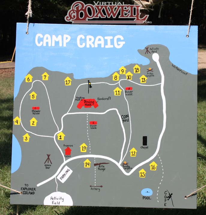
We would be remiss if we did not mention the hand-painted maps found in each camp. We have no idea when the first version of these "Boxwell-made" maps were created. The exception being the Camp Craig map, whose first version was painted by Claus “Dutch” Mann for the 1983 Staff Reunion. The “Boxwell-mades” shown here are the most current versions of these maps. These are not only made by the staff, but are generally updated yearly to reflect small changes at camp. Parnell’s map has been kept in its “classic” mode as an homage to its resident camp days and CubWorld has yet to create such a map (that we are aware of). Regardless their accuracy, these maps are the evolving representations of the summer camp program.